


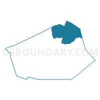
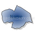
Voting District PRTO, Wilson County, North Carolina
About
Outline

Summary
| Unique Area Identifier | 641870 |
| Name | Voting District PRTO |
| County | Wilson County |
| State | North Carolina |
| Area (square miles) | 46.95 |
| Land Area (square miles) | 46.72 |
| Water Area (square miles) | 0.23 |
| % of Land Area | 99.52 |
| % of Water Area | 0.48 |
| Latitude of the Internal Point | 35.81362080 |
| Longtitude of the Internal Point | -77.82741580 |
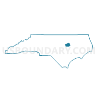
Maps

Graphs
Select a template below for downloading or customizing gragh for Voting District PRTO, Wilson County, North Carolina


Neighbors
Neighoring Voting District (by Name) Neighboring Voting District on the Map
- Voting District 0035, Nash County, NC
- Voting District 1001, Edgecombe County, NC
- Voting District 1301, Edgecombe County, NC
- Voting District 1401, Edgecombe County, NC
- Voting District PRGA, Wilson County, NC
- Voting District PRTA, Wilson County, NC
- Voting District PRWE, Wilson County, NC
- Voting District PRWM, Wilson County, NC
- Voting District PRWR, Wilson County, NC
Top 10 Neighboring County Subdivision (by Population) Neighboring County Subdivision on the Map
- Wilson township, Wilson County, NC (42,775)
- Rocky Mount township, Nash County, NC (16,257)
- Taylors township, Wilson County, NC (9,001)
- Toisnot township, Wilson County, NC (5,462)
- Gardners township, Wilson County, NC (3,870)
- Township 10, Lower Town Creek, Edgecombe County, NC (3,303)
- Township 13, Cokey, Edgecombe County, NC (2,134)
- Township 14, Upper Town Creek, Edgecombe County, NC (1,818)
Top 10 Neighboring Place (by Population) Neighboring Place on the Map
Top 10 Neighboring Unified School District (by Population) Neighboring Unified School District on the Map
- Nash-Rocky Mount Schools, NC (106,786)
- Wilson County Schools, NC (81,234)
- Edgecombe County Schools, NC (45,606)
Top 10 Neighboring State Legislative District Lower Chamber (by Population) Neighboring State Legislative District Lower Chamber on the Map
- State House District 23, NC (75,657)
- State House District 25, NC (73,935)
- State House District 24, NC (62,129)
Top 10 Neighboring State Legislative District Upper Chamber (by Population) Neighboring State Legislative District Upper Chamber on the Map
Top 10 Neighboring 111th Congressional District (by Population) Neighboring 111th Congressional District on the Map
Top 10 Neighboring Census Tract (by Population) Neighboring Census Tract on the Map
- Census Tract 14, Wilson County, NC (8,885)
- Census Tract 6, Wilson County, NC (7,282)
- Census Tract 112, Nash County, NC (6,167)
- Census Tract 7, Wilson County, NC (5,755)
- Census Tract 13, Wilson County, NC (5,587)
- Census Tract 214, Edgecombe County, NC (4,141)
- Census Tract 12, Wilson County, NC (4,021)
- Census Tract 215, Edgecombe County, NC (3,313)
Top 10 Neighboring 5-Digit ZIP Code Tabulation Area (by Population) Neighboring 5-Digit ZIP Code Tabulation Area on the Map
- 27893, NC (39,723)
- 27801, NC (21,740)
- 27803, NC (21,227)
- 27822, NC (8,143)
- 27852, NC (2,977)
- 27878, NC (1,931)